Saturday, September 27, 2008

Cottonwood Lakes, Cirque Peak (12900ft), and Mt. Langley (14026 ft)

A few weeks ago, Stefan and I did a 3 day hike to Cirque Peak and Mt. Langley. This hike went the way a lengthy hike should go, in my opinion. While it started at a busy parking lot, the trail was surprisingly empty and it was also easy to find nice places for setting up the tent. After sleeping the night in the car on the parking lot, we started hiking on Saturday morning, taking the trail to Cottonwood Lakes, which follows the Cottonwood Creek. We arrived at the lakes around 11am. Most of these lakes are just a bit below the tree line at 11k ft, and the bare rock faces rising up behind and around the lakes have interesting patterns. This wilderness is so rich in beauty that people did not even bother to name the lake and the rock shown in this picture.


We setup the tent at Long Lake, and decided to hike up New Army Pass to Cirque Peak since the day was still young and we could nicely acclimatize to the high altitude this way. Not far from our tent, we crossed this little creek.


As we were climbing New Army pass, swiftly moving clouds appeared and we debated whether we might get wet. Luckily, the clouds ultimately remained east, north, and south of our trail. From the top of New Army pass, we took a first look at Mt. Langley. The clouds and the angle of the sun highlighted the rock faces on its south-eastern side.


Patches of little red flowers grow around 11800 ft.


As we hiked over to Cirque peak by following a lengthy ridge, we looked west into Sequoia National Park. For many miles, there are no roads or houses here, or any other signs of civilization - just wilderness, and plenty of fresh air.


We saw yellow flowers on the way to and at Cirque Peak at 12900 ft.


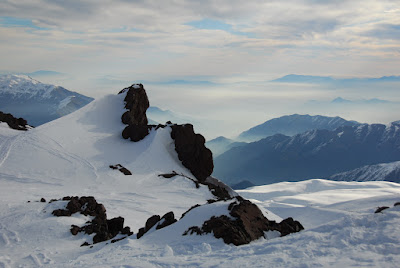
After a little discussion we decided to head down the north side of Cirque Peak, which does not have any trail. I ended up a tiny bit behind while messing around with my camera, ending up just in the right position to take this shot.


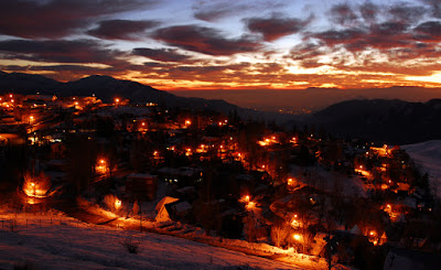
We were back at our camp site before sunset.


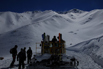
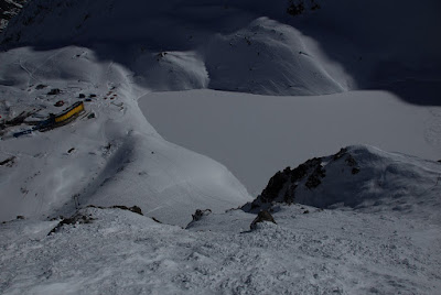
The next morning, we hiked up New Army Pass again, however this time we carried all our equipment because we were planning to come down Old Army Pass and camp at another lake that night. It was very windy throughout the day. This picture shows High Lake.


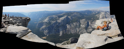
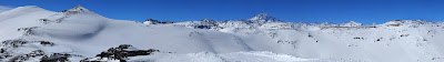
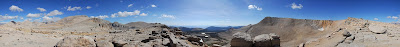
This picture is a panoramic shot from the top of New Army Pass. It starts north, with the lengthy bare mountain that has rock cliffs on its east side being Mt. Langley. Left (west) of that, one can see Mt. Whitney lurking. In the center, Long Lake and the South Fork Lakes are visible. The prominent peak behind the two boulders in the foreground is Cirque Peak - and there is the ridge line leading up to it which we had hiked the previous day.


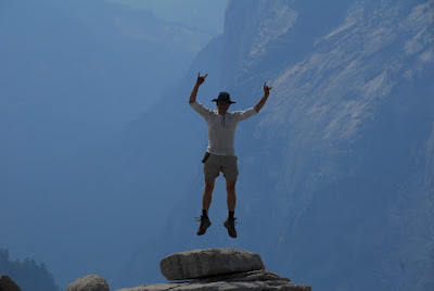
While Langley was in plain sight the whole time, it still took us a while to get there. The wind was blowing hard, and as we took the switch backs and rock scrambles to the top, sometimes it blew in the right direction and sometimes not. Naturally, at the top of the 14er the wind was especially noticeable, though my attempts to take off were unsuccessful.


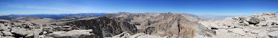
Looking north from Langley, the scenery is even more dramatic. Langley's north face is a cliff, and beyond that there are some lakes and more steep rock faces, and of course Whitney, the highest peak in the lower 48 states. Looking in this direction, it seems improbable how doable the hike up the south side of Langley is.


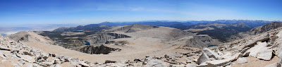
After lunch, we left the top of Langley and hiked towards Old Army Pass, which is in the same general direction as New Army Pass. The peak at the center of this panoramic is Cirque Peak.


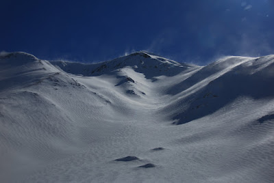
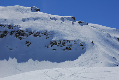
Old Army Pass is a little steeper and the trail is narrower than New Army Pass. The rocks north of it are awesome looking.


We descended back below the tree line and set up camp between Lake 4 and an unnamed lake. This picture shows Langley just before we got to Lake 4.


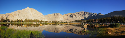
The next morning was spectacular. The wind was gone, and the lakes were now perfect mirrors of the surrounding landscape.


After this gorgeous Monday morning, we hiked back to the parking lot and left the wilderness. Having been to the top of a 14er the day before, the first reaction upon reaching the valley floor near Lone Pine is to look back up the mountains and identify it.


For more pictures, check out my Picasa album of this hike.

Sunday, September 21, 2008

Half Dome, Yosemite

I'm still not done with selecting the pictures from our Mt. Langley hike, but in the meantime I thought I'd put up some from a more recent trip to Half Dome in Yosemite National Park. That day (September 13th), I did not take a lot of pictures because Zbigniew also carried his camera and I was getting a bit lazy after the Langley hike.

In the spring, Vernal Falls is one of the most impressive waterfalls, and the "Misty Trail", which we took to get to Half Dome, pretty much soaks you because it traverses close by. But the main source of water is melted snow, so in the fall, there's no mist on the trail and the waterfall is small by Yosemite standards.


Getting to the top of Half Dome requires getting up this steep granite slope. The cables would make it quick and easy if it wasn't for the crowds of people waiting to make their next step. There are two options, basically. The first is to be very patient and make step after step between the two cables. I believe this takes hours but only tried it for twenty minutes or so. The second option is to go outside the cables, so that way there's just one cable to hold onto but you get to bypass the traffic jam. With that, the climb takes 15 minutes or so.


And sure enough, we made it! This is me celebrating by jumping around on the rock a bit, with Yosemite Valley in the background.


I think Half Dome is easily the most fantastic cliff I've been on. Here's a stitched image that covers a wider angle. Of course, being right next to such a cliff can't really be captured with photography.


While I enjoyed this hike due to this one-of-a-kind massive piece of awesome granite, I have to also mention that the trail is overcrowded to a point where it reduces the fun, at least for me. With this many people around, it seems difficult to get a sense of the surrounding wilderness; basically you hear voices and cellphones all the time. Undeniably it's a great hike, but it does not deliver the experience of being away from the crowds - which is one of the best things about hiking.

For more pics, check out Zbigniew's album and my album.

Monday, September 8, 2008

The Best of the West Ribs Festival in Sparks, Nevada

From Best Of The West 2008


We had an offsite in Tahoe, so Sparks, Nevada was just a small hop away. A few folks from our team went there to taste the most delicious ribs ever. As a returning visitor (I had been there the year before, too) I must say even though ribs aren't usually my favorite food, these are easily worth 8 hours of driving. Apologies to the vegetarians, and thanks for missing out on this good stuff so there's more for the rest of us.

We climbed a 14er that weekend (Mt. Langley) - so even though we ate ribs all day Friday there was no lasting harm done. I'll have pictures later.

Saturday, September 6, 2008

Snowboarding in Chile: El Arpa, Portillo, Valle Nevado, La Parva, and El Colorado

Last season I got into the habit of snowboarding a lot, and when the snow melted and the resorts closed I felt this was a major bummer. So, I decided to try out snowboarding in the Southern hemisphere, taking advantage of the fact that when it's summer up here, it's winter down there. In South America, the snow fun is in Chile and Argentina, so I picked Chile for starters. Chile is an awesome place geographically - I think of it as California compressed into half the width, with the mountains folded up a little higher and steeper in the process.

I booked my trip with CASA Tours, which meant that things were organized front to back by them except for the flight to Santiago. Their guides are bilingual, so I could have gotten by without a word of Spanish, but I picked up a couple language CDs prior to the trip and listened to them in the car and when rollberlading to work. This way, I'd know how to ask ¿Donde esta el baƱo? - not that it's particularly useful when you're out in the snow on some big mountain, but at least it gave a peace of mind. I was very happy with CASA tours - not only do the guides know Spanish but also they're good at finding powder on the mountain, pick good accomodations, organize transportation (in this case either a van or a 4wd suburban), and most importantly: helped us to safely explore off-piste / out of bounds terrain, with the van waiting at the bottom of the run where applicable.

The trip started in Santiago de Chile, which, coming from the US feels almost European. Here's a random shot from walking around the city; large pedestrian malls, friendly climate (note that it's winter!), lots of shops, museums, churches, and all the other things you'd expect from a city.


Musicians played for us while we had excellent Chilean seafood in a restaurant in the fish market.


For the first few nights, we stayed at a historic hacienda in San Esteban, the "Casa San Regis". It's a large, old house with a fireplace, wooden floors that make noises as you walk around, and excellent food. Marcela, the owner, told us the story of the house, which started out as a land grant by the king of Spain - who roughly said "whatever you can see from here in this direction is yours". She also gave us her perspective on more recent Chilean history (Allende, Pinochet).


For the first two days, we skied El Arpa. This place has 4000 skiable acres - all large, open bowls without trees. For comparison, Heavenly has 4900 acres, with lots of trees. But El Arpa has no lifts: except for hiking or skinning up, the only way to get to the top is a snowcat, which can carry around 20 people.


The place is amazing. Here is a panoramic view from the top, which features Aconcagua, the highest mountain outside of Asia.


The slopes we used started out with a fresh coat of powder in the morning. It was good! Typically we didn't reuse a slope, so from the bottom, we could look back up and identify individual lines. In North American resorts, this is definitely pretty rare.


Portillo was next. This is South America's oldest resort, and very famous. It's on the road to Argentina, which is an experience in itself. Just below the resort are some switchbacks which are tight like a bookshelf. The chairlift actually crosses some of these, so as you look down, you might spot a large truck underneath you.


The setting is a lake with the steep mountains rising on both sides, which have the lifts - to the point where the slope gets too steep and rocky to put lifts. Some slopes are only accessible via pomas, which supposedly were designed to scare snowboarders off the mountain. No big deal though, and much better than hiking up.


The remaining days, we went to Valle Nevado, La Parva, and El Colorado. These are three medium-sized resorts which are next to each other, all above the tree line, with views of Santiago de Chile. The evening shot looks from the Farellones (a skier village where we stayed) to Santiago.


The resorts have a few rocks to hike / play around, natural half pipes, and one high speed quad (in Valle Nevado) - the remaining lifts are slow, and often there's T-bars and poma lifts (though not the strange 5 parallel skier contraption as in Portillo). All had some groomed runs, with the one in La Parva being used as a race track. However, by far our best runs were the ones in the Santa Teresita area - this is a slope between the resorts and the road from Farellones to Valle Nevado. We accessed this once from Valle Nevado, and once from El Colorado, and both times it was a long run through fresh snow. I liked the run from El Colorado best - here's the lines we put down; pretty sure the one in the lower left corner of the picture was mine. Thanks a ton to Travis (our guide) for making this happen!


For more photos, check out my Snowboarding in Chile 2008 album.